 Unlike Stonington and Greenport, the commercial fishing fleet in Mattituck consists mostly of smaller, independent, fishing and lobster boats. Difficult to see from land, this fleet is only fully visible from a boat as you make your way along Mattituck Creek. In this photo, the crew of the Phyllis Ann unloads her lobster pots on an August afternoon.
Map
Unlike Stonington and Greenport, the commercial fishing fleet in Mattituck consists mostly of smaller, independent, fishing and lobster boats. Difficult to see from land, this fleet is only fully visible from a boat as you make your way along Mattituck Creek. In this photo, the crew of the Phyllis Ann unloads her lobster pots on an August afternoon.
Map
Monday, August 31, 2009
Phyllis Ann, Mattituck
Unlike Stonington and Greenport, the commercial fishing fleet in Mattituck consists mostly of smaller, independent, fishing and lobster boats. Difficult to see from land, this fleet is only fully visible from a boat as you make your way along Mattituck Creek. In this photo, the crew of the Phyllis Ann unloads her lobster pots on an August afternoon.
Map
Sunday, August 30, 2009


Thursday, August 27, 2009

Tuesday, August 25, 2009
Bicentennial Veterans Park

 This is a small, city park located just east of the Throgs Neck Expressway in the Bronx. The park does not really have a lot to offer, but it does provide a nice view to the east. The land beyond the moored boats is City Island, while the land in the far distance to the right is Kings Point, Long Island. The neighborhood of Edgewater can be seen in the top photo, on the right side. Bicentennial Veterans Park is sometimes referred to as Weirs Creek.
Recreation Parks.net: Map
Bridge And Tunnel Club: Bicentennial Veterans Park (photos)
Wednesday, August 19, 2009
Oyster Boat Columbia


 Oyster boat Columbia, entering Bridgeport Harbor, August 2009
 SOUNDBOUNDER: Steel Point Oyster Fleet
CT HISTORY ONLINE: Oyster Boat Photos
Sunday, August 16, 2009
Mount Misery Cove


Years ago I used to keep a list of place-names along the coast that sounded very downbeat; Cape Disappointment, Dismal Swamp, Desolation Sound, etc. Those names intrigued me and I often wondered what the history was behind them. They also most likely created a public relations problem for the local chamber of commerce. I seem to recall a more juvenile list I kept as well, that included places like Intercourse PA, Maggies Nipples WY, and Hooker OK (those ought to bring some interesting Google hits). One local name I had on that first list was Mount Misery Cove, just east of Port Jefferson.
Mount Misery Cove and the surrounding land is referred to on some maps as McAllister County Park, although I have never heard anyone use that name. It is also called Pirates Cove occasionally.This seems to be a recent phenomenon that I have only become aware of in the past few years. The whole fascination with pirates and buried treasure really bores me. There were never any pirates in Mt Misery Cove; the cove was created in the 20th century by companies that excavated the sand at the base of the bluffs.
We recently dropped anchor in Mount Misery Cove on a late afternoon under overcast skies, with some lightning flashes on the western horizon. The thunderstorms never reached us, but the next morning brought easterly 20 knot winds. Strong winds out of the east often create the roughest conditions on Long Island Sound. Waves roll in from the open ocean and fail to diminish as they make their way down the Sound. There is a lot of open water in an east-west direction. The surrounding bluffs fortunately protected the cove from the full force of the winds. It was a comfortable anchorage.
I rowed ashore around 8 AM and walked much of the park's northern portion. A light rain combined with the high winds was much more apparent along this exposed strip of land. I made my way along the ridge of the bluffs which provided a fantastic view despite the foggy skies. West of me was the Port Jefferson Ferry passing the breakwaters of the harbor. To the north and east was the Sound which looked like the North Atlantic with waves crashing on the beach below. I could hear the roar of the surf, a rare feature for these waters in August. South of me was the anchorage, all quite and calm. No pirates, no misery.
Wikipedia: Belle Terre
Saturday, August 15, 2009


Thursday, August 13, 2009
Liberty Schooner In Greenport


 Liberty Schooner Website
Bowsprite: Schooners Of New York Harbor
Tugster: Day In The Life
Liberty Schooner Website
Bowsprite: Schooners Of New York Harbor
Tugster: Day In The Life
YouTube: Liberty Schooner Sailing Along
Wednesday, August 12, 2009
The Ancient Mariners


Ancient Mariners Fife & Drum, Blessing of the Fleet Parade, Stonington, July 2008
Monday, August 10, 2009
The Schooner Virginia
 The schooner Virginia near Orient Point.
With apologies to the Amistad, the Virginia in my opinion, is the most attractive of all tallships I have seen.
Schooner Virginia Website
Soundbounder: Schooner Virginia Rounding Long Beach Bar
The schooner Virginia near Orient Point.
With apologies to the Amistad, the Virginia in my opinion, is the most attractive of all tallships I have seen.
Schooner Virginia Website
Soundbounder: Schooner Virginia Rounding Long Beach Bar
Sunday, August 9, 2009
Silver Heels


 I don't know much about this boat, other than she was built in Camden, Maine in 1963. I saw her moored in Stonington Harbor recently and I rowed over to take a closer look.
Friday, August 7, 2009
Silver Sands State Park


This was a pleasant surprise. I had never visited Silver Sands State Park in Milford until this summer. The 47 acre park consists of salt marsh, beach, and open fields. In the distance sits Charles Island, a nature preserve which can be reached during low tide.
This is the newest of state parks in Connecticut. Approximately 75 homes stood here before Hurricane Diane destroyed them in 1955. Acquired by the state, portions of the property then served as a landfill during the 1960's and 70's. I am not sure how long the park has been in existence, but I believe it has been only for a decade or so.
Like many state parks, it gets crowded, especially on weekends. But I noticed the crowds thin significantly on the far western end of the beach. Best of all, it is free. There are no admission fees, parking charges, or residency requirements.
I would like to come back here in the autumn months and perhaps explore Charles Island. The 14 acre island can be reached by a tombolo (new word) that extends from the beach.
CT Coastal Access Guide: Silver Sands State Beach
Thursday, August 6, 2009
New London Sailfest


 I did not attend the Sailfest weekend in New London this year.
I did however take some time to motor through the harbor and see some of the ships that were in port for the festivities. The harbor was busy with boat traffic, and the afternoon sun provided a lot of glare. These were not ideal conditions for taking photos.
I did not attend the Sailfest weekend in New London this year.
I did however take some time to motor through the harbor and see some of the ships that were in port for the festivities. The harbor was busy with boat traffic, and the afternoon sun provided a lot of glare. These were not ideal conditions for taking photos.Nonetheless, I was able to see the Virginia, the Quinnipiack, and the Mystic Whaler tied up to the city piers.
Some other events taking place in the upcoming months include:
If you know of others, let me know.
Wednesday, August 5, 2009
Sandra And Michelle
 I see this boat around quite a bit. She was hauled in Mystic for some maintenance earlier this year, and I have seen her in Stonington as well. Noank is her home port and I sometimes spot her heading out long before the sun has risen. This photo caught her returning to port in the afternoon with Morgan Point Lighthouse in the distance.
Tuesday, August 4, 2009
Long Beach Bar Lighthouse
 Long Beach Bar Lighthouse, AKA Bug Light, July,2009
First Lit: 1871
Decommisioned: 1948
Relit: 1993
When I spent a good deal of time in this area 20 years ago, there was no lighthouse here. A fire in 1963 destroyed this light leaving only the foundation and riprap that surrounds the structure. I was fortunate to see it up close for the first time this summer. Reminiscent of the screwpile lighthouses of Chesapeake Bay, the light marks the entrance to the passage seperating Shelter Island from the North Fork.
East End Seaport Foundation
East End Lighthouses
Lighthouse Friends (Map)
Long Island Lighthouses
Long Beach Bar Lighthouse, AKA Bug Light, July,2009
First Lit: 1871
Decommisioned: 1948
Relit: 1993
When I spent a good deal of time in this area 20 years ago, there was no lighthouse here. A fire in 1963 destroyed this light leaving only the foundation and riprap that surrounds the structure. I was fortunate to see it up close for the first time this summer. Reminiscent of the screwpile lighthouses of Chesapeake Bay, the light marks the entrance to the passage seperating Shelter Island from the North Fork.
East End Seaport Foundation
East End Lighthouses
Lighthouse Friends (Map)
Long Island Lighthouses
Monday, August 3, 2009
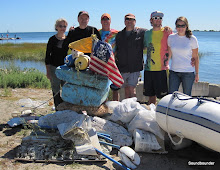
Greenport Fishing Fleet


 As I have noted in other posts, there are not too many commercial fishing fleets left in this region. The few that remain have become smaller and smaller. Greenport still maintains a fleet with a dock that is accessible from the center of the village. I took these photos from a small park located behind the train station.
Greenport has a busy waterfront. Along with the recreational boats, there are ferries, excursion boats, and fishing boats coming and going at a steady rate.
The Mt Vernon (blue hull) I recognize from another port. I will have to look through my photos of Stonington, Pt Judith, and New Bedford to find where I have seen her before.
SOUNDBOUNDER: Stonington Fishing Fleet
Loving Long Island: Greenport
New York Times: Weekender (2002)
Sunday, August 2, 2009
Cedar Point Lighthouse
 I usually do not write about the lighthouses that I post on here. There are several websites and books that do an excellent job describing their history, engineering, and lore. I see no point in creating a post that is nothing more than a book report of the information gathered from other sources. It seems more honest and direct to simply provide links to sites that already provide the story. Cedar Point Lighthouse in East Hampton is an exception.
I spent several summers in the mid-to-late 1980's working on a large motoryacht docked in Sag Harbor. A Sunday afternoon cruise or a voyage to Nantucket required us to pass this lighthouse before setting a course east or northwest. The abandoned lighthouse was no longer an official navigational aid, but it was a landmark and a photogenic one at that. I shot photos of it many times; early morning orange, afternoon sun, foggy dusk. I was always intrigued by it. The owner and his guests never seemed to share my enthusiasm. They viewed it more like a wilting red autumn tree you might pass along the highway driving to a Lake Tahoe resort to see Peter Allen.
I knew right then that I would never be filthy rich. I had emotional attachments to all the wrong things. Historic buildings, public space, coastal access, walkable towns....my head was in the wrong place!
Fast forward 20+ years:
I saw some photos online of a restored Cedar Point Lighthouse. Postcards, Christmas cards, real estate brochures etc, all showed a fully renovated and restored structure. I was excited to see it.
Unfortunately, like much of the content on the internet, the images were photoshopped to give the building a pristine appearance. Sometimes the information age is really the misinformation age. The lighthouse is in worse shape than it was in 1987. There are holes in the roof and the structure is crumbling.
In one of the wealthiest areas of the country, during a 20 year period of record DJIA returns, it is sad to think the money was instead spent on foie gras, heliports, diamond lined swimming pools, and Ronald Perelman parties.
Lighthouse Friends (Map)
Long Island Lighthouses
I usually do not write about the lighthouses that I post on here. There are several websites and books that do an excellent job describing their history, engineering, and lore. I see no point in creating a post that is nothing more than a book report of the information gathered from other sources. It seems more honest and direct to simply provide links to sites that already provide the story. Cedar Point Lighthouse in East Hampton is an exception.
I spent several summers in the mid-to-late 1980's working on a large motoryacht docked in Sag Harbor. A Sunday afternoon cruise or a voyage to Nantucket required us to pass this lighthouse before setting a course east or northwest. The abandoned lighthouse was no longer an official navigational aid, but it was a landmark and a photogenic one at that. I shot photos of it many times; early morning orange, afternoon sun, foggy dusk. I was always intrigued by it. The owner and his guests never seemed to share my enthusiasm. They viewed it more like a wilting red autumn tree you might pass along the highway driving to a Lake Tahoe resort to see Peter Allen.
I knew right then that I would never be filthy rich. I had emotional attachments to all the wrong things. Historic buildings, public space, coastal access, walkable towns....my head was in the wrong place!
Fast forward 20+ years:
I saw some photos online of a restored Cedar Point Lighthouse. Postcards, Christmas cards, real estate brochures etc, all showed a fully renovated and restored structure. I was excited to see it.
Unfortunately, like much of the content on the internet, the images were photoshopped to give the building a pristine appearance. Sometimes the information age is really the misinformation age. The lighthouse is in worse shape than it was in 1987. There are holes in the roof and the structure is crumbling.
In one of the wealthiest areas of the country, during a 20 year period of record DJIA returns, it is sad to think the money was instead spent on foie gras, heliports, diamond lined swimming pools, and Ronald Perelman parties.
Lighthouse Friends (Map)
Long Island Lighthouses
The Virginia Rounding Long Beach Bar

I have not posted in a while . I was away for part of the month, and then had no computer access when I returned. The good news is that I visited quite a few places, and accumulated lots of new material. One area I have not paid much attention to on this blog is the east end of Long Island. I was fortunate this July however, to spend an entire week under brilliant skies, bouncing between the North and South Forks, as well as Shelter Island.
Sailing into Orient Harbor, I spotted the Schooner Virginia leaving anchorage and sailing south around Long Beach Bar Lighthouse. Just days earlier, I had seen her docked in New London for the annual Sailfest weekend. Sometimes when you are sailing, the world becomes very small.
Soundbounder: Schooner Virginia
Subscribe to:
Comments (Atom)


