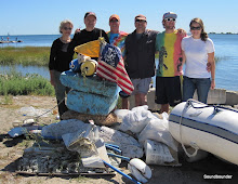
 The Hartford Courant had a story yesterday about an oysterman in Westport. To call it a story about oystering would be somewhat misleading. It is a quick read that touches many subjects.
With Thanksgiving upon us, I found it to be very apropos.
The story is here. No Longer Archived
A photo gallery is here.
The Hartford Courant had a story yesterday about an oysterman in Westport. To call it a story about oystering would be somewhat misleading. It is a quick read that touches many subjects.
With Thanksgiving upon us, I found it to be very apropos.
The story is here. No Longer Archived
A photo gallery is here.
Tuesday, November 25, 2008
An Oysterman's Lament
The Hartford Courant had a story yesterday about an oysterman in Westport. To call it a story about oystering would be somewhat misleading. It is a quick read that touches many subjects.
With Thanksgiving upon us, I found it to be very apropos.
The story is here. No Longer Archived
A photo gallery is here.
Shore Road Walkway Along Hempstead Harbor
 I always like when I stumble across something I was not even looking for. North of Tappen Beach is a simple walkway with benches that skirts along Hempstead Harbor, connecting Sea Cliff to Glenwood Landing. It does not appear on any maps I have looked at, and is not mentioned on any park website. It does not appear to even have an official name. A helpful worker at Tappen Beach told me that it is sometimes called The Walkway, or the Shore Road Walkway. Whatever the name may be, it provides unobstructed views of Hempstead Harbor and the Sound beyond.
Although I did not measure the distance, the walkway appears to extend about a mile-and-a-half. A string of park benches run along the seawall.
There is no parking allowed on Shore Road or Prospect Avenue. Your best bet is to park in Sea Cliff, past the north end of the path, or at Tappen Beach during the off-season. If you happen to discover the official name, be sure to let me know.
HAPPY THANKSGIVING!
I always like when I stumble across something I was not even looking for. North of Tappen Beach is a simple walkway with benches that skirts along Hempstead Harbor, connecting Sea Cliff to Glenwood Landing. It does not appear on any maps I have looked at, and is not mentioned on any park website. It does not appear to even have an official name. A helpful worker at Tappen Beach told me that it is sometimes called The Walkway, or the Shore Road Walkway. Whatever the name may be, it provides unobstructed views of Hempstead Harbor and the Sound beyond.
Although I did not measure the distance, the walkway appears to extend about a mile-and-a-half. A string of park benches run along the seawall.
There is no parking allowed on Shore Road or Prospect Avenue. Your best bet is to park in Sea Cliff, past the north end of the path, or at Tappen Beach during the off-season. If you happen to discover the official name, be sure to let me know.
HAPPY THANKSGIVING!
Sunday, November 23, 2008
Some Stories In The News
Here are some news items I read this week.
New London Day: North Dumpling Island Energy Independence
New Haven Register: Shoreline Trail Gets $100,000
Suffolk Times: Opposition To East Marion Hotel & Resort
Connecticut Post: No Higher Fee For Fairfield Beaches
Stamford Harbor Boat Parade
Mystic Boat Parade
Port Jefferson.com: Residents Petition Harborfront Developement
Also, Tom Andersen at SPHERE has a story about Greenwich boat owners who do not like ospreys nesting near them.
Friday, November 21, 2008
Sands Point Preserve

 " The old order changeth, yielding place to new." I have always thought it is a strange legacy to be best remembered for a extravagant house. A lifetime described through chandeliers and marble statues for busloads of later generations to gawk at. An imprint of the individual that is measured in square footage and acreage. An existence remembered more for the lifestyle than for the life.
Tuesday, November 18, 2008
Playland To Expand Shore Access
 The New York Times and the Journal News both reported last week that county owned Playland Park in Rye will switch to an admission fee system next year for the amusement section. Budget shortfalls and amusement parks are not really my specialty, but what caught my eye was what the NY Times reported in the fifth paragraph of the story.
The Times wrote:
"The county will also open the park's shoreline from the Ice Casino to the Edith Read Sanctuary to the public for the first time and make it accessible year-round. Currently, only a third of the almost mile-and-a half stretch of beach is open to the public when the amusement park is operating between May and September."
I visited Playland in October, and one of the first things I noticed was that a gate had been installed on the road that leads to the Edith Read Sanctuary. One could still walk past the gate, but the small lot that kayakers use was no longer accessible. It will be interesting to see just how "accessible" the shoreline becomes, but this certainly sounds like very good news.
Another thing that caught my eye in the Times story was the comment made by Parks Commissioner Joseph A Stout. He stated:
"This will create the longest stretch of public access beach on either side of the Long Island Sound"
My first reaction was to wonder whether that is really true. It doesn't seem possible. Al Smith/Sunken Meadow Park in Suffolk County certainly has more beach. Even Pelham Bay Park in the Bronx has longer stretches of public access beach. Either the statement is false, or it is a carefully phrased comment that I am not fully grasping.
I will have to look into this further.
The New York Times and the Journal News both reported last week that county owned Playland Park in Rye will switch to an admission fee system next year for the amusement section. Budget shortfalls and amusement parks are not really my specialty, but what caught my eye was what the NY Times reported in the fifth paragraph of the story.
The Times wrote:
"The county will also open the park's shoreline from the Ice Casino to the Edith Read Sanctuary to the public for the first time and make it accessible year-round. Currently, only a third of the almost mile-and-a half stretch of beach is open to the public when the amusement park is operating between May and September."
I visited Playland in October, and one of the first things I noticed was that a gate had been installed on the road that leads to the Edith Read Sanctuary. One could still walk past the gate, but the small lot that kayakers use was no longer accessible. It will be interesting to see just how "accessible" the shoreline becomes, but this certainly sounds like very good news.
Another thing that caught my eye in the Times story was the comment made by Parks Commissioner Joseph A Stout. He stated:
"This will create the longest stretch of public access beach on either side of the Long Island Sound"
My first reaction was to wonder whether that is really true. It doesn't seem possible. Al Smith/Sunken Meadow Park in Suffolk County certainly has more beach. Even Pelham Bay Park in the Bronx has longer stretches of public access beach. Either the statement is false, or it is a carefully phrased comment that I am not fully grasping.
I will have to look into this further.
November

"November always seemed to me the Norway of the year."
EMILY DICKINSON
Hauling a boat is a ritual that I often try to postpone. When the calendar reaches November, a strain of denial seems to overtake me. I become convinced that there will be plenty of warm days ahead. I try to remind myself of the years when I sailed on Thanksgiving weekend. A few peppers still growing in the garden reinforce this delusion. Unfortunately, the calendar and the thermometer do not lie. Sailors, like aging starlets and men with bad combovers, need to acknowledge the passing of time.
The sail from Noank to the Connecticut River boatyard is an easy one. It is the preparations that are most consuming. I needed to make sure the yard had a dock space available. I also had to make arrangements for getting back to Noank to retrieve my car. Finally I had to dig through my bedroom closet for gloves, a wool hat, and the rest of my winter wardrobe. A gentle autumn day on land can sometimes feel like January just a few miles from the shoreline.
November is lonely on the water. An occasional commercial boat is the only other vessel you may see. The shoreline in the distance seems deserted too. Gone are the crowds that flocked to these beaches just six weeks ago. Waterfront homes that overflowed with guests, look empty and silent. Their awnings and Adirondack chairs have been removed from the lawn. Only an occasional whiff from a fireplace tells you that someone is home. A lighthouse that seemed like a quaint image for artists and tourists in June, becomes a utilitarian navigation aid in November.
November is also a sad month on the water. No matter how enjoyable the time might be, you know the days are numbered. This year is no different, as my day is spent looking back in time, rather than forward. I think of my trip to the Thimble Islands, and a starry night anchored in West Harbor. Any sort of thought to suppress my approaching winter ashore. The seasons of the year have come full circle.
I arrived in Saybrook without a hitch, and made my way to the train station the next morning.
It was a spectacular fall day with sunny skies and temperatures in the 60's. As the train passed through Niantic, Long Island Sound came into full view. There were several boats in the distance, taking advantage of the lovely weather. For a brief moment, I started thinking that I should drive back to Saybrook and take one more sail. There would certainly be enough time, and it would be a shame to waste such a nice day. Eventually I realized that this would not be possible since I had already removed the sails from the boat. My sailing season was over, and there was no way to delay its inevitable end. But in spirit, it never ends.
Sunday, November 16, 2008
Thoughts & Rambles: Larchmont Manor Park


Whenever opposition to public access arises, I always think of Manor Park in Larchmont. For those of you not familiar, Manor Park is a privately owned and maintained, 13 acre space situated along the southwest entrance to Larchmont Harbor. There is no charge to enter the park during any season. Visitors do not need to first make a trip to the town hall with a utility bill, car registration, and bank statement to show proof of residency. There is no attendant at the entrance who charges $7 on weekdays and $9 on weekends. There is not even a fence around the park.
Manor Park is free for everyone, but it is not a free-for-all. There are rules, and plenty of them. Aside from the usual "dogs must be leashed" and "no ball playing" rules, the park also bans picnicking, blankets, chairs, food, and beverages. There is no biking, skating, fishing, or swimming allowed either. You cannot launch a kayak or sailboard from the park. Wedding photography requires a permit. Parking is not allowed on the streets that border the park.
The only activities allowed seem to be walking, sitting, reading, and thinking. The cynic in me says that the rules are just a backhanded way of discouraging visitors. The idealist in me says that the rules are fine. If the Larchmont Manor Park Society truly wanted to keep out nonresidents, they could have installed a wrought iron gate with a card key system similar to Gramercy Park. According to the their website, the society receives no money from any government agency. It is within their right to restrict visitors, but they have not done so. The cynic in me is wrong this time.
A common theme heard in the coastal access debate is that small town parks need to restrict nonresidents because residents of nearby larger cities would overwhelm the park. If they wanted , Larchmont could make that claim too. The village borders the city of New Rochelle, while the Bronx line is only about a 6 mile drive down Boston Post Road. White Plains is less than 10 miles north via Rte 125. In all of my visits to Manor Park, it has never seemed crowded or overwhelmed.
I realize that this is not a perfect argument due to the limited recreation available at Manor Park. Anyone looking to spend a Saturday swimming and picnicking is certainly not going to consider Manor Park. But then again, not everyone who visits Greenwich Point or Bayley Beach is looking to swim and picnic. Some visitors just want to walk, or read, or take in the scenery. Greenwich and Rowayton are not interested in what you plan to do, they simply do not want you there.
Another common argument is that the residents of Greenwich accept no state or federal money to maintain their parks, therefore they are free to restrict access. As I earlier noted, the Larchmont Manor Park Society receives no government money and could legally impose similar restrictions if they chose to. To their credit, they have not done so.
If you visit, be sure to respect the rules that are posted, and be careful to observe the parking signs. Your best bet is to park on one of the cross streets, two or three blocks north. A hidden benefit here is that you will be able to view some of the Victorian and center hall Colonials that line the Manor. The striated rocks that border the shore make for a beautiful scene. The stone walls and steps that wind through the park complement the beauty. Manor Park is truly unique, and it is open to everyone at no charge. That is a rare commodity in this vicinity. Just be sure to leave your cooler and beach towel at home.
Manor Park Web Album
Soundbounder: Umbrella Point
Saturday, November 15, 2008
Charles W. Morgan Hauled For Restoration
 The Charles W. Morgan is to undergo a $2.5 million restoration at Mystic Seaport. The 113 foot vessel is the worlds last remaining wooden whaleship. Built in 1841, the Charles W. Morgan was last restored in the 1980s. The ship was hauled last month, and the restoration project is expected to last three years. Visitors will be able to view the project from a a large ramp that will run parallel to the hull. A New York Times photo gallery documents the hauling.
photo:Wikipedia
The Charles W. Morgan is to undergo a $2.5 million restoration at Mystic Seaport. The 113 foot vessel is the worlds last remaining wooden whaleship. Built in 1841, the Charles W. Morgan was last restored in the 1980s. The ship was hauled last month, and the restoration project is expected to last three years. Visitors will be able to view the project from a a large ramp that will run parallel to the hull. A New York Times photo gallery documents the hauling.
photo:Wikipedia
Friday, November 14, 2008
Trail Of Fears
 Even simple things become complicated. The New London Day had a story on Friday about residents along Groton Long Point Road opposing a three foot wide trail through the Mortimer Wright Preserve that would connect to Haley Farm State Park. The residents brought up a list of concerns ranging from traffic to contaminated wells. Call me naive, but I did not realize that these footpaths could be so destructive.
The Day reports:
"Resident Bobbi Jo Cini said Wednesday she has concerns about horses using the trail, fearing manure could affect her well and wetlands on the Wright property. She also said the town would need state Department of Transportation permits for a trail to cross a state road. Groton Long Point Road "is not safe" she said, as cars tend to speed and even get into accidents. "Who is going to be liable for that?" she asked.
Resident Frank Jannarone , who mows the parking area for the trail, also opposed the proposal, saying the current trail system is adequate and used frequently. He also said mountain bikes could damage the area."
Usually nature preserves are a win-win situation. They protect open space, and provide a natural environment for the public to enjoy. Adjacent landowners often benefit from them in the form of higher property values. Residents never have to worry about looking out their kitchen window at a cul-de-sac of McMansions and power lines. The trade off is that the land is open to the public.
The residents in this story want to have it both ways. They like the privacy and the wooded environment that the preserve provides, but they do not want to encourage access. They prefer that the nature preserve remains a wooded extension of their own property. I cannot help but suspect that their environmental concerns are manufactured. Has there ever been a case of well water being contaminated by an occasional horseback rider?
I am sure there are legitimate concerns that need to be addressed. No one wants the trail to become a hangout for vandals or teenage parties (the recent vandalism at Mianus River State Park comes to mind). No one wants the land to become a littered mess that does more harm than good. I would respect those concerns. What I do not respect is someone creating a bunch of false alarms in the name of environmentalism.
Even simple things become complicated. The New London Day had a story on Friday about residents along Groton Long Point Road opposing a three foot wide trail through the Mortimer Wright Preserve that would connect to Haley Farm State Park. The residents brought up a list of concerns ranging from traffic to contaminated wells. Call me naive, but I did not realize that these footpaths could be so destructive.
The Day reports:
"Resident Bobbi Jo Cini said Wednesday she has concerns about horses using the trail, fearing manure could affect her well and wetlands on the Wright property. She also said the town would need state Department of Transportation permits for a trail to cross a state road. Groton Long Point Road "is not safe" she said, as cars tend to speed and even get into accidents. "Who is going to be liable for that?" she asked.
Resident Frank Jannarone , who mows the parking area for the trail, also opposed the proposal, saying the current trail system is adequate and used frequently. He also said mountain bikes could damage the area."
Usually nature preserves are a win-win situation. They protect open space, and provide a natural environment for the public to enjoy. Adjacent landowners often benefit from them in the form of higher property values. Residents never have to worry about looking out their kitchen window at a cul-de-sac of McMansions and power lines. The trade off is that the land is open to the public.
The residents in this story want to have it both ways. They like the privacy and the wooded environment that the preserve provides, but they do not want to encourage access. They prefer that the nature preserve remains a wooded extension of their own property. I cannot help but suspect that their environmental concerns are manufactured. Has there ever been a case of well water being contaminated by an occasional horseback rider?
I am sure there are legitimate concerns that need to be addressed. No one wants the trail to become a hangout for vandals or teenage parties (the recent vandalism at Mianus River State Park comes to mind). No one wants the land to become a littered mess that does more harm than good. I would respect those concerns. What I do not respect is someone creating a bunch of false alarms in the name of environmentalism.
Deja Vu In Darien

 It has been twenty plus years since I last visited Weed Beach in Darien. The 22 acre park and beach on Noroton Neck appeared exactly how I remember it. The tide was low, and so was the sun, as I walked along the shoreline. Cove Island Park, several miles away by land, was just a short distance to the west. Several gulls hunted the mudflats, keeping an eye on my presence as they searched for an afternoon meal. South of me was a large rock outcropping painted by the tides in green and brown, from the waist down. Some trees sprouted from the crevices, their roots clawing through the rock in search of soil. Something seemed awfully familiar.
I was not aware of John Frederick Kensett (1816-1872) when I visited here twenty years ago. In fact, I first learned of him from a New York Times article in 2001. Since then, I have learned of his work, along with his later years spent living and painting in Darien. Kensett lived on Contentment Island, which is on the eastern end of the Darien shoreline. Long Neck Point, the Fish Islands, and Scott's Cove are the subjects of some of his later works. But what about Study On Long Island Sound (above)? Are the rocks at Weed Beach depicted in this painting?
Anyone familiar with the Connecticut shoreline knows that "rocky" is the first adjective used in almost every description. From Hell Gate to Penfield Reef, one has to think long and hard to come up with a stretch of shoreline that is void of exposed bedrock and glacial erratics. Weed Beach is no exception. Perhaps this is all a coincidence. I have found no mention of Kensett in my research of Weed Beach, and the people I have asked, offered no insight. A woman walking her German Shepherd near the rocks, seemed to be reaching for pepper spray when I asked her about this. Not only did she never answer my question, she never even acknowledged it.
Most likely, Kensett was painting a scene near his studio on Contentment Island. That would be the logical scenario. But as I made my way home along Nearwater Lane, I passed a jogger about my age, and thought, "hey, that looks like a guy I went to school with".
Weed Beach Web Album
It has been twenty plus years since I last visited Weed Beach in Darien. The 22 acre park and beach on Noroton Neck appeared exactly how I remember it. The tide was low, and so was the sun, as I walked along the shoreline. Cove Island Park, several miles away by land, was just a short distance to the west. Several gulls hunted the mudflats, keeping an eye on my presence as they searched for an afternoon meal. South of me was a large rock outcropping painted by the tides in green and brown, from the waist down. Some trees sprouted from the crevices, their roots clawing through the rock in search of soil. Something seemed awfully familiar.
I was not aware of John Frederick Kensett (1816-1872) when I visited here twenty years ago. In fact, I first learned of him from a New York Times article in 2001. Since then, I have learned of his work, along with his later years spent living and painting in Darien. Kensett lived on Contentment Island, which is on the eastern end of the Darien shoreline. Long Neck Point, the Fish Islands, and Scott's Cove are the subjects of some of his later works. But what about Study On Long Island Sound (above)? Are the rocks at Weed Beach depicted in this painting?
Anyone familiar with the Connecticut shoreline knows that "rocky" is the first adjective used in almost every description. From Hell Gate to Penfield Reef, one has to think long and hard to come up with a stretch of shoreline that is void of exposed bedrock and glacial erratics. Weed Beach is no exception. Perhaps this is all a coincidence. I have found no mention of Kensett in my research of Weed Beach, and the people I have asked, offered no insight. A woman walking her German Shepherd near the rocks, seemed to be reaching for pepper spray when I asked her about this. Not only did she never answer my question, she never even acknowledged it.
Most likely, Kensett was painting a scene near his studio on Contentment Island. That would be the logical scenario. But as I made my way home along Nearwater Lane, I passed a jogger about my age, and thought, "hey, that looks like a guy I went to school with".
Weed Beach Web Album
Thursday, November 13, 2008
The Amistad In Noank
 If only every morning started out this way. I just returned to the docks following my morning ritual of newspapers, coffee, and walking, when I saw the two masted schooner. It was the Amistad, a recreation of the eighteenth century ship made famous in the 1997 film starring Morgan Freeman. It was an impressive sight.
The Amistad had just undergone repairs at Mystic Seaport, and was preparing to sail north to the Canadian Maritimes for the summer of 2008. In 2007, the ship embarked on a transAtlantic voyage that included stops in England, West Africa, and the Caribbean. Her home port is New Haven.
More information on the Amistad, including an itinerary, can be found here.
Amistad In Noank Web Album
If only every morning started out this way. I just returned to the docks following my morning ritual of newspapers, coffee, and walking, when I saw the two masted schooner. It was the Amistad, a recreation of the eighteenth century ship made famous in the 1997 film starring Morgan Freeman. It was an impressive sight.
The Amistad had just undergone repairs at Mystic Seaport, and was preparing to sail north to the Canadian Maritimes for the summer of 2008. In 2007, the ship embarked on a transAtlantic voyage that included stops in England, West Africa, and the Caribbean. Her home port is New Haven.
More information on the Amistad, including an itinerary, can be found here.
Amistad In Noank Web Album
Stamford: A Tale Of Two Parks

 I visited Cove Island Park in Stamford yesterday. It is a beautiful space that combines open lawns and a sandy beach, with a rocky shoreline and tidal marsh. I walked the perimeter of the park, stopping briefly to watch the waters of Holly Pond retreat through the falls of the old tide mill. It made for a beautiful afternoon.
With plenty of daylight remaining, I decided to stop at Cummings Park which is about two miles away. It might as well have been 50 miles away. The park was empty, with the exception of a few parked cars and an occupant who kept staring at me. The fishing pier was in ruins, picnic tables were broken, and every structure seemed rusted, and in need of painting. The buildings had all the charm of a department of motor vehicles.
I realize that every park is not going to be as nice as Cove Island. But I do question how one park can be so beautifully maintained, while another is allowed to decay? I think I know the answer to my question, but this is my first post, and I was hoping to avoid politics!
Web Album: Cummings Park
and Cove Island Park
I visited Cove Island Park in Stamford yesterday. It is a beautiful space that combines open lawns and a sandy beach, with a rocky shoreline and tidal marsh. I walked the perimeter of the park, stopping briefly to watch the waters of Holly Pond retreat through the falls of the old tide mill. It made for a beautiful afternoon.
With plenty of daylight remaining, I decided to stop at Cummings Park which is about two miles away. It might as well have been 50 miles away. The park was empty, with the exception of a few parked cars and an occupant who kept staring at me. The fishing pier was in ruins, picnic tables were broken, and every structure seemed rusted, and in need of painting. The buildings had all the charm of a department of motor vehicles.
I realize that every park is not going to be as nice as Cove Island. But I do question how one park can be so beautifully maintained, while another is allowed to decay? I think I know the answer to my question, but this is my first post, and I was hoping to avoid politics!
Web Album: Cummings Park
and Cove Island Park
Subscribe to:
Posts (Atom)


